Old Photos For No Reason Whatsoever

All advertisments are hidden for logged in members, why not log in/register?


Hic up, hopefully photo nowView attachment 96634
The alley you refer to XM was called unsurprisingly, Black Swan yard. I think the arguement over the years, was the new Black Swan built on the footprint of the old one or not. If so, where's Bank Street in regards to the photo
 
The alley you refer to XM was called unsurprisingly, Black Swan yard. I think the arguement over the years, was the new Black Swan built on the footprint of the old one or not. If so, where's Bank Street in regards to the photo
Bank St is to the left on the photo.
On the OS map, which we know will be spot on, the alley is not quite half way down Snig Hill from Bank St to West Bar. As the address indicates, 39-41 this pub was never at the corner of Bank St and Snig Hill, unlike the rebuilt one we all know and used.
Apologies for not putting the map up, unfortunately my technical abilities don't allow. Must try harder.
The discussion regarding the footprint of the new and old appears to be yes and no as the rear of the new is over the old but the entrance of the new is not. There were shops or a shop between corner of Bank St. and the old, blitzed, Black Swan.
Hope that makes sense.
 
Last edited:
I love the car making the dangerous pull out in front of the bus. The number plate, DWA reminded me that Sheffield had its own registration numbers, these being W, WA, WB, WC, WE and WJ (If I remember correctly). Nowadays we have Y registrations for Yorkshire which includes us Leeds and ,oddly, Beverley.

Our Renault 16 was a WC in more ways that one ,for a bonus point what was our dialing code ?
 
Hic up, hopefully photo nowView attachment 96634

I've attached an old OS map of the area. As you can see there is a public house marked on the map which is not quite on the corner of Bank Street and Snig Hill. Immediately above the pub appears to be the little Lane you refer to and which can be seen in your photo. It looks like the original Black Swan was slightly lower down Snig Hill and was then rebuilt on the corner of Bank Street and Snig Hill.
IMG_0401.PNG
Edit. While faffing trying to find the OS map you've already replied
 
I've attached an old OS map of the area. As you can see there is a public house marked on the map which is not quite on the corner of Bank Street and Snig Hill. Immediately above the pub appears to be the little Lane you refer to and which can be seen in your photo. It looks like the original Black Swan was slightly lower down Snig Hill and was then rebuilt on the corner of Bank Street and Snig Hill.
View attachment 96656
Edit. While faffing trying to find the OS map you've already replied
Excellent, thank you, good job some can work these buggering computers.
What year is this map? Suspect it's after 1940 as believe the corner of Bank St and Snig Hill was built up previously and the vacant lot, shown on this map was created by the action of the blitz.
The map is also good as it gives the street numbers and according to the book APOECorner the original pub was Nos. 39-41, all helps to build the picture we are assembling.
 
The OS maps are from the 1950s. They are on the Sheffield History site, but they are a bugger to use.
 
Excellent, thank you, good job some can work these buggering computers.
What year is this map? Suspect it's after 1940 as believe the corner of Bank St and Snig Hill was built up previously and the vacant lot, shown on this map was created by the action of the blitz.
The map is also good as it gives the street numbers and according to the book APOECorner the original pub was Nos. 39-41, all helps to build the picture we are assembling.
post-513-1180945804 (1) (1).jpg
Map of where the bombs fell in mid December over 2 nights in 1940. The Luftwaffe obviously had it in for the Blades as they got part of the stand at the Lane, direct hit on the Marples, that sold Magnet, and took the top floors off the Cossack and Black Swan, strange nothing fell north of the dog trackpost-513-1180945804 (1) (1).jpg
 
View attachment 96659
Map of where the bombs fell in mid December over 2 nights in 1940. The Luftwaffe obviously had it in for the Blades as they got part of the stand at the Lane, direct hit on the Marples, that sold Magnet, and took the top floors off the Cossack and Black Swan, strange nothing fell north of the dog trackView attachment 96659

The industrial east end must have been the German target. It's said that the government were able to use tactics and so divert the bombers away from the east end and bomb residential areas. People were more disposable than our steel works during the war.

The economy v. the health of the nation. Sound familiar?
 
An old bloke to me a few months ago.a house got hit with a bomb on Whitehouse lane-Burgoyne road. the next day he was listening to the radio.
lord, hor hor was on Germany calling. he mentioned the house that got bombed. even called the tenants name out. Bleeding traitor.
 
The industrial east end must have been the German target. It's said that the government were able to use tactics and so divert the bombers away from the east end and bomb residential areas. People were more disposable than our steel works during the war.

The economy v. the health of the nation. Sound familiar?
Looks like they were after Laycocks because they made stuff for Spitfires, then went after Arnold Lavers woodyard because they were future Blades sponsors and the Blades pubs on London Road, Eccy Road and West Street !!
 
Excellent, thank you, good job some can work these buggering computers.
What year is this map? Suspect it's after 1940 as believe the corner of Bank St and Snig Hill was built up previously and the vacant lot, shown on this map was created by the action of the blitz.
The map is also good as it gives the street numbers and according to the book APOECorner the original pub was Nos. 39-41, all helps to build the picture we are assembling.
XM657, Ecl,
I dont know if this map extract helps. It's from the Nat. Library of Scotland site, which I find very useful at times.
I'm not sure of the exact date but it must be before 1928 because on another section of the same map it shows fields where my house, built in that year, now stands.

Screenshot_20201101-093123_Samsung Internet.jpg
 
Looks like they were after Laycocks because they made stuff for Spitfires, then went after Arnold Lavers woodyard because they were future Blades sponsors and the Blades pubs on London Road, Eccy Road and West Street !!
An old Uncle of mine worked at Vickers, and during the early part of the war their drop hammer was under constant armed guard. He wasn't told why at the time, but after the war he found out they were making Spitfire crankshafts and the hammer needed protecting at all costs.
 

The industrial east end must have been the German target. It's said that the government were able to use tactics and so divert the bombers away from the east end and bomb residential areas. People were more disposable than our steel works during the war.

The economy v. the health of the nation. Sound familiar?
The Germans bombing campaign was to terrorise the indigenous populations, they flew along triangulated pre set radio beams which took them to their target but not with pin point accuracy. The idea then was to unleash the load, hoping to cause as much devastation as possible. Incendiaries first, then they could see what they were doing and also as a guide for later waves of a/c.
I once stood on the top of the Hyde Park Flats looking over the city centre and it came to mind that if the Luftwaffe had turned right over the city they would have had the whole of the East End at their mercy, it was all laid out in front of me.
In 1940 I wouldn't think we had a jamming device but as the war progressed no doubt means were available.
As regards the health of the nation, like the war, people are dying and will die, no one can stop that. What I think matters is 'if' we get through this, like we did the war, the ones left will have some thought for those who didn't make it, as they are and will have contributed to the well being of the majority.
 
View attachment 96673
Been rummaging through some old family papers earlier, came across this.
To my eldest brother, I don't think they're interested he's 71 now!
The way they're playing at the moment you never can tell. :) Be an email now though wouldn't it.
Nice to have the John Harris signature.
 
XM657, Ecl,
I dont know if this map extract helps. It's from the Nat. Library of Scotland site, which I find very useful at times.
I'm not sure of the exact date but it must be before 1928 because on another section of the same map it shows fields where my house, built in that year, now stands.

View attachment 96664
Your a star you mate, use the same maps myself, but you clearly show there were 3 shops from Bank St. to the original BS.
Oh to be technically adept. Thank You.
 
In 1940 I wouldn't think we had a jamming device but as the war progressed no doubt means were available.
Google "Battle of the Beams" - I am sure there is a book about this as well

We used to generate our own Beams to confuse the German Aircrews ......

attempting to get them to drop their Bombs off the designated target
 
Google "Battle of the Beams" - I am sure there is a book about this as well

We used to generate our own Beams to confuse the German Aircrews ......

attempting to get them to drop their Bombs off the designated target
An old guy I knew from your neck of the woods used to tell me a tale that they used to go out into the fields outside of Retford and roll out giant rolls of what can only be described as bin bag plastic to simulate the River Trent so the Luftwaffe bombed that instead of the Trent which would have resulted in widespread flooding of the low lying areas, I'm sure we would have employed the same deception on other major rivers.
 
The neepsend gas holders two massive ones.men were on top of them making sure nothing landed incendiary bombs etc.really brave men. if they went up
Parkwood springs Penistone road infirmary road part of Walkley would have gone.at that time mostly houses then. would have been a massive loss of life.
 
Your correct Bert Grimsby is aways a got day out. always bleeding cold though.
 

Bloody hell, thats my first match. Dad finished work early, which was unusual, stood on the terrace.
The west terrace, baiting the pool fans on the Lane End, errr no, different era.
That’s a great picture, didn’t realise it was such a packed crowd. Ron Yeats No 5?
I think Liverpool were promoted that season, it was
the start of their rise under Shankly.
Shaw G, 2 penalties both at the Kop end.
How in Gods name have I remembered that?
 
What a long fucking winter that was . I never want to see the like of it again .


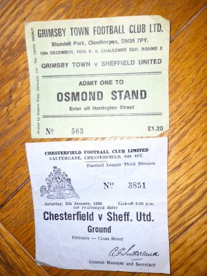
One abiding memory is that , even though no matches were played for what seemed like forever because of the frozen grounds , they kept on doing the FA Cup draw . So you would turn on the radio and hear some bloke solemnly pronouncing that the first draw out of the hat for the 5th round was , for example , “ Sheffield United or Chesterfield or Liverpool or Barnsley ...versus .... Chelsea or Blyth Spartans or Aston Villa or Wrexham .” :)

Tried to play Bolton in the 3rd round, about a dozen times.
Finally played in March.
Got the programme with a series of dates crossed out
 

All advertisments are hidden for logged in members, why not log in/register?

All advertisments are hidden for logged in members, why not log in/register?

Back
Top Bottom