Navigation
Install the app
How to install the app on iOS
Follow along with the video below to see how to install our site as a web app on your home screen.
Note: This feature may not be available in some browsers.
More options
Style variation
You are using an out of date browser. It may not display this or other websites correctly.
You should upgrade or use an alternative browser.
You should upgrade or use an alternative browser.
Old Photos For No Reason Whatsoever
- Thread starter Bert
- Start date
All advertisments are hidden for logged in members, why not log in/register?
Eddiecolquhounsleg
Well-Known Member
- Joined
- May 18, 2017
- Messages
- 3,020
- Reaction score
- 8,298
Western Bank. Didn't realise we had lost what looks like a Georgian terrace to make way for what I think is called the Alfred Denny building
oaklandrdblade
Active Member
Remember the watch and sports sales in Channing HallThink this is Tuckwoods store on Fargate. I can't remember this place, all I remember is Tuckwoods restaurant on Surrey Street which was a genteel sort of place with waitresses in black and white uniforms.
It was upstairs next to the Montgomery theatre (I think). Also upstairs, a little bit further along Surrey Street is Channing Hall. Quite a large exhibition space which is accessed by a rather grand staircase
View attachment 36004
View attachment 36003
SouthEssexBlade
...for wit and sage wisdom
Western Bank. Didn't realise we had lost what looks like a Georgian terrace to make way for what I think is called the Alfred Denny building
Aye, a fine row of Georgian Terraced houses went in the 60s or early 70s. That whole area had quite a lot of residential properties that went as the city increased and hospital buildings were needed, coupled with the ever expanding university.
From almost the same spot, this is now

I found an aerial photograph of that area from the early 1920s. The quality isn't great but you can see how much residential property there was in that area, and how rural it was.

Tunstall Fred
Well-Known Member
- Joined
- Feb 10, 2017
- Messages
- 3,943
- Reaction score
- 6,797
Aye, a fine row of Georgian Terraced houses went in the 60s or early 70s. That whole area had quite a lot of residential properties that went as the city increased and hospital buildings were needed, coupled with the ever expanding university.
From almost the same spot, this is now
I found an aerial photograph of that area from the early 1920s. The quality isn't great but you can see how much residential property there was in that area, and how rural it was.

So where the all weather pitches are now,opposite Westen Bank Hospital,it was a boating lake!!
bornablade
Well-Known Member
- Joined
- Jan 24, 2014
- Messages
- 4,806
- Reaction score
- 10,028
Aye, a fine row of Georgian Terraced houses went in the 60s or early 70s. That whole area had quite a lot of residential properties that went as the city increased and hospital buildings were needed, coupled with the ever expanding university.
From almost the same spot, this is now
I found an aerial photograph of that area from the early 1920s. The quality isn't great but you can see how much residential property there was in that area, and how rural it was.

I'm trying to locate St Marks Church and King Edwards School (both on Glossop Road) on that photo.
Working from the Children's, down to the bottom of that road where the West End pub (now Doctors Orders?) is and then a right - somewhere up there should be the church and King Teds.
SouthEssexBlade
...for wit and sage wisdom
Woodthorpe blade
"Goodnight, goodbye and may your God go with you"
- Joined
- Aug 22, 2015
- Messages
- 918
- Reaction score
- 2,123
Eddiecolquhounsleg
Well-Known Member
- Joined
- May 18, 2017
- Messages
- 3,020
- Reaction score
- 8,298
So where the all weather pitches are now,opposite Westen Bank Hospital,it was a boating lake!!
I think it was a dam rather than a boating lake. There were a series of dams in the valley to service the population of Sheffield as it grew.
The boating lake in Crookes Valley Park was one of those dams and unlike most boating lakes is something like 60 feet deep in the middle!!
SouthEssexBlade
...for wit and sage wisdom
SouthEssexBlade
...for wit and sage wisdom
I think it was a dam rather than a boating lake. There were a series of dams in the valley to service the population of Sheffield as it grew.
The boating lake in Crookes Valley Park was one of those dams and unlike most boating lakes is something like 60 feet deep in the middle!!
There was a series of them, as you say the last of which became Crookes Valley Park boating lake. This photo is poor quality as well, but you can see the dams, starting on the left with Godfrey.

bornablade
Well-Known Member
- Joined
- Jan 24, 2014
- Messages
- 4,806
- Reaction score
- 10,028
That lady in the brown coat might be offended by this photo
SouthEssexBlade
...for wit and sage wisdom
Here's a more recent aerial photo, if that helps identify anything


Hamburg Blade
Well-Known Member
ok, I give up. What's the white car behind the wall?
bornablade
Well-Known Member
- Joined
- Jan 24, 2014
- Messages
- 4,806
- Reaction score
- 10,028
Here's a more recent aerial photo, if that helps identify anything

No Octagon Centre.
SouthEssexBlade
...for wit and sage wisdom
No Octagon Centre.
Quite a few things are different I think. I said it was more recent not up-to-date
SouthEssexBlade
...for wit and sage wisdom
ok, I give up. What's the white car behind the wall?
Before my time. Vauxhall Victor?
Hamburg Blade
Well-Known Member
Before my time. Vauxhall Victor?
Good shout. Before my time too, but I'd looked at Fords and Vauxhalls and missed the early sixties Victor.
georgebernardshaw
Well-Known Member
- Joined
- Apr 30, 2012
- Messages
- 14,977
- Reaction score
- 24,811
ok, I give up. What's the white car behind the wall?
Vauxhall Shitehawk
SouthEssexBlade
...for wit and sage wisdom
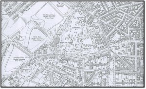
Map of roughly the above circa 1903
View attachment 36026
Old Great Dam became the boating lake, I reckon.
The wall is on Northumberland Road & (most of it) is still there, along with the missing stones every 100 yards or so that were left out in order to act as an overflow for the dams
Correct, the,main clue is the location of the Dam in relation to Harcourt Road.Old Great Dam became the boating lake, I reckon.
Tunstall Fred
Well-Known Member
- Joined
- Feb 10, 2017
- Messages
- 3,943
- Reaction score
- 6,797
Many thanks for the posts about the Dams boys,my other half,a Crooksonian finds it fascinating,she can remember the motor boat on Crookes Valley Park.
Hamburg Blade
Well-Known Member
HighfieldBlade
Well-Known Member
I used to call her "bag lady", but does anyone else remember the old woman who regularly sat on a wall on Woodhead Rd near the post office on London Rd, feeding the pigeons? Probably she was there on matchdays too. I'm talking mid 70's.
Eddiecolquhounsleg
Well-Known Member
- Joined
- May 18, 2017
- Messages
- 3,020
- Reaction score
- 8,298
Before my time. Vauxhall Victor?
Definitely a Vauxhall Victor.
At the upper right of this picture is what we called The Rec. it was an area of scrubby grass and red shale (if I remember correctly) and hurt like shit if you fell over on it.There was a series of them, as you say the last of which became Crookes Valley Park boating lake. This photo is poor quality as well, but you can see the dams, starting on the left with Godfrey.

At the Crookes Valley Park side of the road were steep banks down to the dam itself which we used to " Roly poly" down, if that term makes sense to anybody!!!
Tunstall Fred
Well-Known Member
- Joined
- Feb 10, 2017
- Messages
- 3,943
- Reaction score
- 6,797
Definitely a Vauxhall Victor.
At the upper right of this picture is what we called The Rec. it was an area of scrubby grass and red shale (if I remember correctly) and hurt like shit if you fell over on it.
At the Crookes Valley Park side of the road were steep banks down to the dam itself which we used to " Roly poly" down, if that term makes sense to anybody!!!
Many times doing a roly poly encountered shog dit,not nice
Seem to remember the Rec having a disused youth club on it, by the time it was demolished, it had been so badly vandalised that not much was left for the demolition team.Definitely a Vauxhall Victor.
At the upper right of this picture is what we called The Rec. it was an area of scrubby grass and red shale (if I remember correctly) and hurt like shit if you fell over on it.
At the Crookes Valley Park side of the road were steep banks down to the dam itself which we used to " Roly poly" down, if that term makes sense to anybody!!!
Eddiecolquhounsleg
Well-Known Member
- Joined
- May 18, 2017
- Messages
- 3,020
- Reaction score
- 8,298
Many times doing a roly poly encountered shog dit,not nice
Yes. It defines us as Unitedites. The Wednesdayites would roll down the hill and come up smelling of roses with a long lost half crown lodged behind their ears
Similar threads
- Replies
- 120
- Views
- 15K
- Replies
- 42
- Views
- 2K
- Replies
- 125
- Views
- 14K
All advertisments are hidden for logged in members, why not log in/register?


