vorpal blade
Well-Known Member
- Banned
- #781
Why, are you after an abdominal belt mate?
Follow along with the video below to see how to install our site as a web app on your home screen.
Note: This feature may not be available in some browsers.
All advertisments are hidden for logged in members, why not log in/register?
Where's that?
Why does Fitzalan Square seem to be smaller nowadays?
Why does Fitzalan Square seem to be smaller nowadays?
Why does Fitzalan Square seem to be smaller nowadays?
The Target certainly was rough but it was on Hyde Park along with the Crows Nest, Earl Francis, Samuel Plimsoll and Park Gardeners WMC. The pubs on Park Hill were the Link, Parkway, Scottish Queen and Earl George,
The Barleycorn was another like the Cossack but also used by working girls, as was the old Minerva Tavern.
I was hoping a few on here a bit older than me might pin it down. The building on the left is the Yorkshire Electric building.

You did when those chub got their head down5 hour match, you'd need them
Looks like it's you and me against the rest, mate
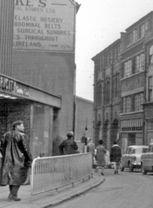
Post-war rebuilding of the damaged High Street was slow; it was not until 1951 that the damaged Walsh's store was demolished with a new store designed by JS Beaumont and built by George Longden Ltd., opening on 13 May 1953. A new Marples Hotel opened in 1959 while C&A Modes also rebuilt their store, although the building is now occupied by Primark. The early 1960s saw a radical change to High Street's junction with Angel Street when a decision was taken to give cars easier access to the city centre. This involved the creation of Arundel Gate, a dual carriageway which approached from the south and met the High Street / Angel Street junction at a roundabout. These changes resulted in the demolition of Change Alley, an ancient thoroughfare which ran between High Street and Norfolk Street and had had timber framed houses on it many years previously.[7]
I was hoping a few on here a bit older than me might pin it down. The building on the left is the Yorkshire Electric building.
Virgin Records and Lewis Leathers were down there in the 70's.
I think it was that road from Church St to Leopold St it's no longer there lost it when they built Orchard SquareI was hoping a few on here a bit older than me might pin it down. The building on the left is the Yorkshire Electric building.
Bradley's was the record shop neat the Yorkshire Bank
You could right mukka.Ran from Fitzalan Square to Norfolk Street
You could right mukka.
Something I spotted there's a Gestapo/ SS agent on the left hand side of the photo
It was on that block but not the last one.That's the top of Fargate. There's a Yorkshire Bank right at the bottom of the Moor. The last building before it bends round towards the Lydon, I mean Dempseys.
I thought Virgin was on that block, the last one after Cumberland Street.
its all changed.I have no idea where Change Alley is
It was on that block but not the last one.

View attachment 21666
I thought that the wall at the end of the street in this photo looked a bit like that building ?
I know the Luftwaffe had a go, but I don't think I know a city centre in England where the planners finished their job off for them as ruinously as they did in Sheffield..... believe me, as an outsider, in a car, the street plan has all the clarity & logic of a snakes and ladders board that got muddled up with the Times crossword.
Hence my earlier comment about the way the Manpower Services Commission building strangled the Moor.
All advertisments are hidden for logged in members, why not log in/register?
