Navigation
Install the app
How to install the app on iOS
Follow along with the video below to see how to install our site as a web app on your home screen.
Note: This feature may not be available in some browsers.
More options
Style variation
You are using an out of date browser. It may not display this or other websites correctly.
You should upgrade or use an alternative browser.
You should upgrade or use an alternative browser.
Old Photos For No Reason Whatsoever
- Thread starter Bert
- Start date
All advertisments are hidden for logged in members, why not log in/register?
Maurice Maurice
Active Member
- Joined
- Nov 17, 2021
- Messages
- 1,941
- Reaction score
- 7,516
Tickhill Blade
Active Member
- Joined
- Apr 26, 2019
- Messages
- 2,374
- Reaction score
- 6,716
Tickhill Blade
Active Member
- Joined
- Apr 26, 2019
- Messages
- 2,374
- Reaction score
- 6,716
HarryHaslam
Well-Known Member
- Joined
- Feb 1, 2017
- Messages
- 4,618
- Reaction score
- 13,390
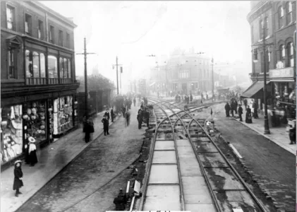
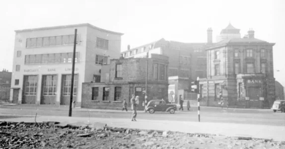
Tough one to work out for a minute. Thought the building centre was the firework place or the Thai restaurant but think it’s a little further up and is a cafe or something now but was the tile shop for years?
Maurice Maurice
Active Member
- Joined
- Nov 17, 2021
- Messages
- 1,941
- Reaction score
- 7,516
Tickhill Blade
Active Member
- Joined
- Apr 26, 2019
- Messages
- 2,374
- Reaction score
- 6,716
No I think it is what pre-dated the firework place. They are laying the tram tracks, London Road to the left, Ecclesall Road first right, Cemetery Road second right.Tough one to work out for a minute. Thought the building centre was the firework place or the Thai restaurant but think it’s a little further up and is a cafe or something now but was the tile shop for years?
Tickhill Blade
Active Member
- Joined
- Apr 26, 2019
- Messages
- 2,374
- Reaction score
- 6,716
I've seen the footage of this tram ride from 1902 before and I'm sure it's been posted in this thread. But someone has used AI to enhance it and it's absolutely fantastic
Trigger Blade
Cheerful twaddle
He certainly did, as did The Grease Band, including falsetto harmonies, no Sue and Sunny to do themWho is it ?
That festival was almost certainly Joe Cocker’s finest hour when he put on a stunning performance .
There is a Joe Cocker/John Sebastian in that Joe recorded Sebastian’s “Darling Be Home Soon” on his 2nd album. In my view, one of the most beautiful love songs ever written.
In fact, just checked and Sebastian did it in his set at Woodstock, Joe didn’t.
Last edited:
bornablade
Well-Known Member
- Joined
- Jan 24, 2014
- Messages
- 4,779
- Reaction score
- 9,953
My immediate thought - it was Broomhill (although the tram may not have run that far), looking towards town with the York pub in the centre.No I think it is what pre-dated the firework place. They are laying the tram tracks, London Road to the left, Ecclesall Road first right, Cemetery Road second right.
I'm still puzzled to where this is.
Help, please. Road names. Thank you.
stringjunior
A Stringer original
Me tooI'm still puzzled to where this is.
Help, please. Road names. Thank you.
Tickhill Blade
Active Member
- Joined
- Apr 26, 2019
- Messages
- 2,374
- Reaction score
- 6,716
Bottom of the Moor, or South Street. The tracks going off to the left is London Road, the first set on the right is Ecclesall Road and the second set is Cemetery Road (the trams went to Nether Edge until 1935).I'm still puzzled to where this is.
Help, please. Road names. Thank you.
The tram video above goes over those tracks in the opposite direction from 36secs in
Eddiecolquhounsleg
Well-Known Member
- Joined
- May 18, 2017
- Messages
- 3,001
- Reaction score
- 8,194

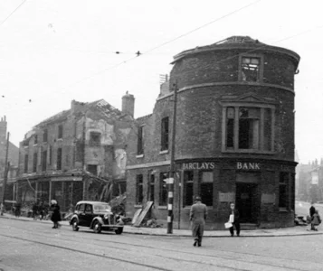
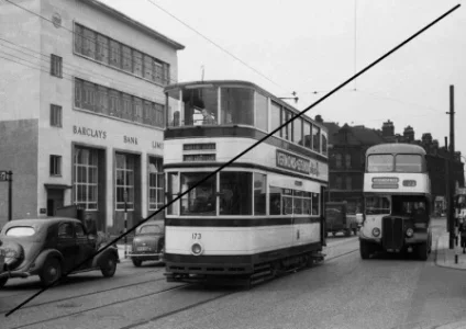
I think this photo is a bit clearer for that junction. The building to the left, behind the double decker, is what replaced the building in the middle of the tram laying photo and is on the junction of London Road and Cemetery Road. The building in the middle, with the curved portico, is the current Thai restaurant on the junction of Cemetery Road and Ecclesall Road. And, of course, the light building on the right of the photo is the S & E Co-op, known commonly as ‘The Stoors’.
Trigger Blade
Cheerful twaddle
The Thai restaurant was Midland Bank wasn’t it?View attachment 201449
I think this photo is a bit clearer for that junction. The building to the left, behind the double decker, is what replaced the building in the middle of the tram laying photo and is on the junction of London Road and Cemetery Road. The building in the middle, with the curved portico, is the current Thai restaurant on the junction of Cemetery Road and Ecclesall Road. And, of course, the light building on the right of the photo is the S & E Co-op, known commonly as ‘The Stoors’.
What strikes me now, but never did at the time, is that the Co-op was nowhere near the centre of town and was presumably a real pull for shoppers to come right down to the bottom end of The Moor, at least before the MSC building was built.
Eddiecolquhounsleg
Well-Known Member
- Joined
- May 18, 2017
- Messages
- 3,001
- Reaction score
- 8,194
Yes. It was a Midland Bank before it became a restaurant and the other building, which is now the Sheffield Fireworks Co was, I think, a Barclays. The S&E was the ‘go too’ place for school uniforms, if I recall right. We couldn’t afford Cole’s 
 . It was a great place to go and is what Meadowhall would call an ‘Anchor tenant’ in that you would have to walk past loads of other shops before you got to it. Yes, it was very popular and a sad loss both commercially and architecturally.
HarryHaslam
Well-Known Member
- Joined
- Feb 1, 2017
- Messages
- 4,618
- Reaction score
- 13,390
Tickhill Blade
Active Member
- Joined
- Apr 26, 2019
- Messages
- 2,374
- Reaction score
- 6,716
HighfieldBlade
Well-Known Member
I've seen the footage of this tram ride from 1902 before and I'm sure it's been posted in this thread. But someone has used AI to enhance it and it's absolutely fantastic
Opening scene of video is instantly recognisable as Heeley Bottom/Lowfield School, then cuts to London Rd/Alderson Rd junction. Fascinating to watch.
Wapping Blade
Well-Known Member
We seemed to live in the S&E or the B&C in town with my grandma!Yes. It was a Midland Bank before it became a restaurant and the other building, which is now the Sheffield Fireworks Co was, I think, a Barclays. The S&E was the ‘go too’ place for school uniforms, if I recall right. We couldn’t afford Cole’s. It was a great place to go and is what Meadowhall would call an ‘Anchor tenant’ in that you would have to walk past loads of other shops before you got to it. Yes, it was very popular and a sad loss both commercially and architecturally.
JFK
Member
And I'm still narked about it.We were at the top of the league on the day JFK got shot
Stoney Blade
New Member
- Joined
- Dec 28, 2022
- Messages
- 13
- Reaction score
- 8
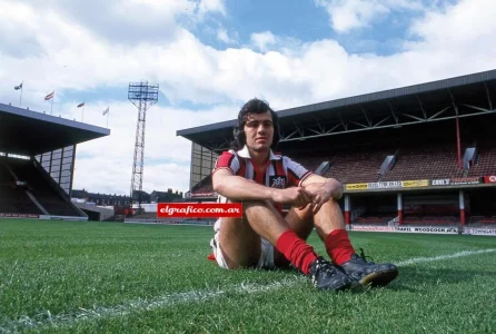
That Sabella photo....was lucky to see him play but was he partly responsible for us being relegated?
Tickhill Blade
Active Member
- Joined
- Apr 26, 2019
- Messages
- 2,374
- Reaction score
- 6,716
Tickhill Blade
Active Member
- Joined
- Apr 26, 2019
- Messages
- 2,374
- Reaction score
- 6,716
Eddiecolquhounsleg
Well-Known Member
- Joined
- May 18, 2017
- Messages
- 3,001
- Reaction score
- 8,194
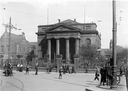
Bottom of the Moor? In your post of the tram track laying earlier there is a series of posts and railings which look suspiciously like the ones forming the outside perimeter of this church. Presumably this was lost during the war, or cleared shortly after the war ended.
Tickhill Blade
Active Member
- Joined
- Apr 26, 2019
- Messages
- 2,374
- Reaction score
- 6,716
Yes that's the same spot, I think it might have been damaged in the War bombing but it was still there in 1952 when it was a furniture store. Presumably it was demolished for the ring road late 50sBottom of the Moor? In your post of the tram track laying earlier there is a series of posts and railings which look suspiciously like the ones forming the outside perimeter of this church. Presumably this was lost during the war, or cleared shortly after the war ended.

Last edited:
jim2007
Member
- Joined
- Sep 11, 2012
- Messages
- 702
- Reaction score
- 1,647
For context, here's that area on the OS 1:1250 post-war resurvey of Britain (changed a bt):Bottom of the Moor? In your post of the tram track laying earlier there is a series of posts and railings which look suspiciously like the ones forming the outside perimeter of this church. Presumably this was lost during the war, or cleared shortly after the war ended.
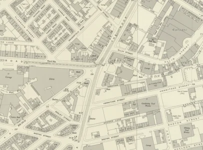
Reproduced with the permission of the National Library of Scotland
bornablade
Well-Known Member
- Joined
- Jan 24, 2014
- Messages
- 4,779
- Reaction score
- 9,953
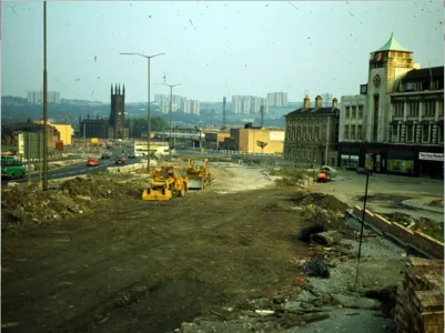
Just about where those yellow diggers are is where I was born.
Eddiecolquhounsleg
Well-Known Member
- Joined
- May 18, 2017
- Messages
- 3,001
- Reaction score
- 8,194
I like that the Ordnance Survey refers to the S&E as The Stores, a name I referred to in an earlier post colloquially as The StoorsFor context, here's that area on the OS 1:1250 post-war resurvey of Britain (changed a bt):
View attachment 201507
Reproduced with the permission of the National Library of Scotland
Isaw Joeshaw
Old School Blade
- Joined
- May 17, 2017
- Messages
- 5,205
- Reaction score
- 14,567
I like that the Ordnance Survey refers to the S&E as The Stores, a name I referred to in an earlier post colloquially as The Stoors.
Alternatively known as the Coap as opposed to Co-op .
Similar threads
- Replies
- 120
- Views
- 15K
- Replies
- 125
- Views
- 13K
All advertisments are hidden for logged in members, why not log in/register?


